A campus app for universities offers intelligent functions for finding lecture halls, offices and bicycles.
AT A GLANCE
- 2D/3D building maps
- seamless indoor/outdoor navigation within the campus
- “Buddy Finder” function to share the location
PROBLEM DEFINITION
Several thousand students travel on a large campus every day. The same number of bikes and cars will be parked in the parking spaces provided for them. Those who are new to the university usually miss their first lecture due to disorientation don’t find the Student Secretariat and don’t know what to eat in the canteen. Most campus areas are not necessarily small and clearly arranged, which can make it difficult to start the semester.
SOLUTION
Using a mobile app, students, teachers and visitors can start a guided tour from their current location. Lecture halls, offices and pool rooms as well as other POIs (e.g. canteen, libraries) can be selected as navigation destinations. The possibility to share your location with fellow students or teachers makes it easier to arrange appointments or meeting points. Upon arrival, students or visitors can use seamless indoor and outdoor navigation – from the bike park or parking lot directly to their contact person’s location.
In addition, students can access the canteen menus via the campus app and thus know what is currently on the menu in the campus canteen. App users can also download their personal course plan to their smartphone or check their grades for upcoming and cancelled events by entering their matriculation number.
TECHNICAL IMPLEMENTATION
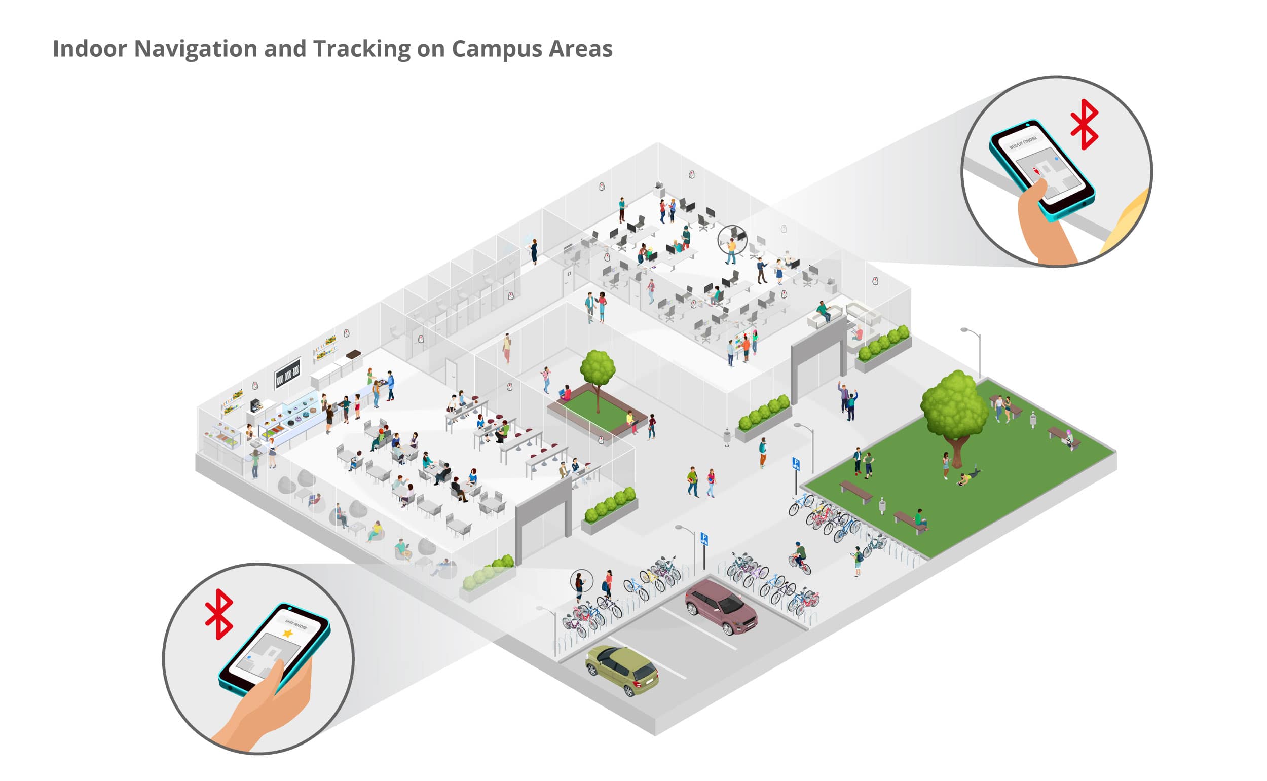
Bluetooth Low Energy Beacons are installed on the walls of the university building. For navigation, a mobile device (smartphone) receives Bluetooth signals from the beacons and uses the signal strength measurement for localization. An app is required for this. Location- and time-based push messages are sent to the user’s smartphone via a return channel. The user can also save the position of the bike or car on a map so that the user can find his bicycle or car as quickly as possible.
The “Buddy Finder” function allows you to release your own position. If this is activated, App users can see the location of the person they are looking for on the map and can also select them directly as navigation destinations or contact them via the app. Current information, such as course cancellations, can be sent to users’ smartphones via an existing return channel, e.g. via a push message.
Optionally, the collected data can also be sent to the infsoft LocAware platform® for intelligent further processing.


